Coming from the town of Liezen, the entrance to the Gesäuse, the breakthrough valley of the Enns, is flanked by the rugged limestone peaks of the Hochtor group and Admonter Reichenstein group on the right and the Buchstein group on the left. The latter extends over the main summit, which can be seen from afar, the Großer Buchstein (2224 m / 7296 ft), around 10 kilometers (6.2 mi) to the east to the Tamischbachturm (2035 m / 6676 ft). The Buchstein Group is part of the Ennstal Alps and is one of four mountain groups in the so-called Gesäuse and thus also part of the Gesäuse National Park.
First of all: The paths to the Großer Buchstein are long and exhausting. It doesn't matter whether you choose St. Gallen / Eisenzieher in the north or Gstatterboden in the south as the starting point, you have to calculate around 5 hours for the ascent. The tour described here starts in the small town of Gstatterboden in the middle of the Gesäuse National Park. To be more precise, at the parking lot next to the National Park Pavilion (EUR 6 for a day ticket, as of 2023). From here, you first walk past the train station on a sidewalk between the tracks and the main road to the Enns Bridge. There the road is crossed and you follow hiking trail 641 on a gravel path in the direction of Buchsteinhaus.

After about 800 m (0.5 mi), you turn right onto a gravel path and keep to the left to immediately turn onto a forest path. Hiking trail 641 now leads steadily uphill through the forest. The path is in good condition throughout and is pleasant to walk on. Again and again, gravel roads and, at least in summer, mostly dried-up creeks are crossed. After about 4.8 kilometers (2.9 mi), the path once again leads into a gravel road, which you follow uphill until after the next hairpin bend.
Finally, the valley station of the material cable car to the Buchsteinhaus is in sight. But before you reach it, the path branches off to the right once more into the forest. Now the last, somewhat monotonous section of the ascent to the managed hut, the Buchsteinhaus, at 1571 m (5154 ft) above sea level, begins. The path zigzags up to the hut in countless serpentines.
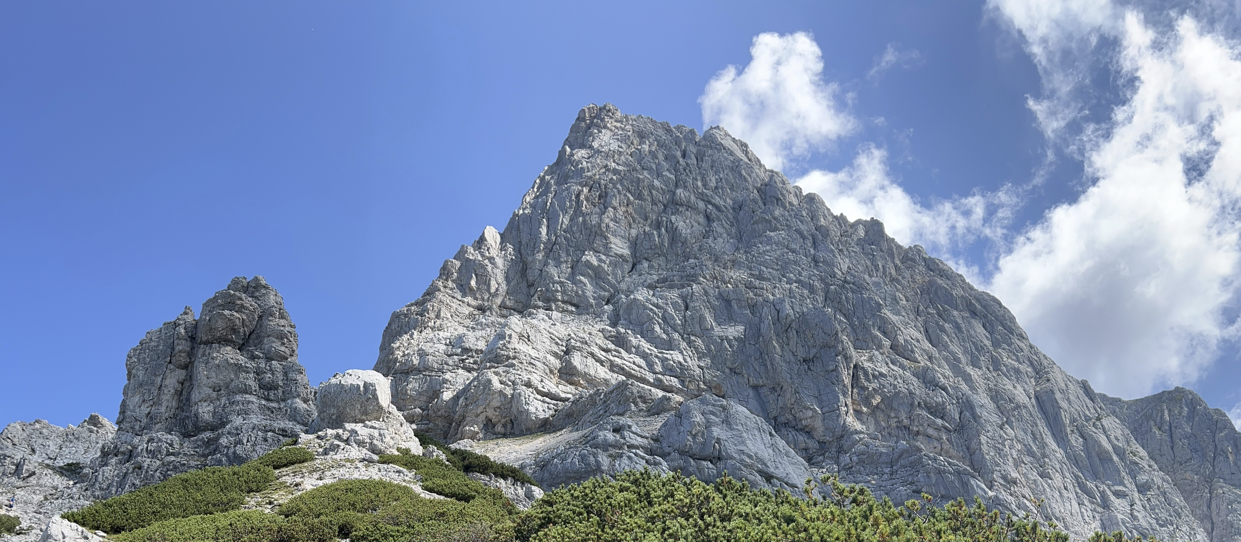
In general, the entire ascent to the Buchsteinhaus is rather unspectacular. Apart from a few places where you have a good view of the steep north face of the Hochtor group, the path runs in the consistently shady forest, which can be an advantage, especially on hot days. After the Buchsteinhaus is reached after about 2.5 hours, that changes abruptly. At this point, almost 1000 meters (3280 ft) in altitude have already been overcome and now the south face of the Großer Buchstein and the surrounding alpine landscape come into focus.

From now on, hiking trail 641 shows its increasingly rough side. It goes steeper uphill over so-called Schrofen terrain (steep terrain, strewn with rocks and rock outcrops). In between, the path is gravel, well marked and cannot really be lost from sight. At the same time, the panorama above the Buchsteinhaus is breathtaking. In particular, the views of the Hochtor group and the Admonter Reichenstein group and the Enns valley are magnificent. After about an hour, a signpost points the way to the entrance to the Südwandband via ferrata (B/C) at an altitude of around 1970 m (6463 ft).

The route leads up the south face of the Großer Buchstein via a diagonal band system. The via ferrata itself is not very difficult, but a particularly exposed cross path, two steep climbs and a gully that has to be descended offer a few tricky spots.
A head for heights and sure-footedness are of course required, especially since the entire via ferrata allows very impressive views down. In general, the via ferrata is almost entirely secured with a fixed steel rope and the rocks offer sufficient holds and steps.
When you get off the via ferrata, you still have to climb a few meters unsecured before you finally reach the impressive karst plateau. From here it is not far to the summit. Markings show the way along the ridge until the summit cross is finally in sight.
After a total of about 5 hours, the summit of the Großer Buchstein (2224 m / 7296 ft) is finally reached and, as expected, the view is magnificent. Once again, the nearby peaks of the Hochtor (2369 m / 7772 ft) and the Admonter Reichenstein (2251 m / 7385 ft) catch the eye. The Enns valley lies at your feet and the Haller Mauern, the Totes Gebirge, the striking Grimming and even the Dachstein glacier can be seen very well when looking west.
No less impressive is the view to the east of the large karst plateau and the peaks of the Buchstein group: St. Gallner Spitzen (2144 m / 7034 ft), Kleiner Buchstein (1990 m / 6528 ft), Tieflimauer (1820 m / 5971 ft) and Tamischbachturm (2035 m / 6676 ft).

The descent is not via the via ferrata, but via the normal route 641 (UIAA I). First you follow the red-white-red markings over rocky terrain down to the Buchstein saddle. There you follow the signpost towards Buchsteinhaus and descend into the impressive western gorge.
The way through the gorge is to be enjoyed with great caution. The path is very steep and a lot of loose rock makes the descent difficult. The risk of falling rocks or the risk of triggering a rockfall is omnipresent in this section. Some places have to be climbed down, others are at least secured with fixed steel ropes. The 1st degree of difficulty according to the UIAA scale is quite appropriate.

Finally, exit the western gorge heading south. The path hugs the western rock face of the Buchstein summit. Sometimes downhill, sometimes uphill, the path leads over a lot of gravel and loose rock back to the signpost that has pointed the way to the start of the via ferrata a few hours earlier.

After passing this point, the path becomes a little more pleasant and familiar again. The path leads downhill between mountain pines over rugged terrain and gravel in the direction of the Buchsteinhaus. The view is magnificent the whole time. Not only the surrounding mountains, but also the beauty of the surrounding terrain are a source of great pleasure.
Finally, the Buchsteinhaus comes into view and only a few last turns of the trail stand in the way of a proper refreshment in this managed hut. This pays off, by the way: the menu is not too big, but the cuisine is excellent. Incidentally, the Buchsteinhaus is also often used for overnight stays, which means that the quite demanding day tour can also be divided into 2 days.
The further descent back in Enns valley is also via the ascent path and meanders through the forest down into the valley. The good condition of the path makes the descent relatively easy and, above all, much less strenuous than those in the sections above the Buchsteinhaus.

After around 8.5 hours (not counting the breaks on the summit and in the Buchsteinhaus), the starting point of the tour, the car park in Gstatteboden, is reached again. This also marks the end of a grandiose as well as challenging tour. Finally, it should be noted that the long and somewhat monotonous ascent to the Buchsteinhaus definitely paid off. The via ferrata is great and should be considered as an alternative to the descent from the summit, given the tedious and dangerous descent via the normal route through the western gorge.
Tour Facts (Tracked with Bergfex Tours):
Distance: 19,3 km (~ 12 mi)
Duration: 08:30 h (without breaks)
Ascent altitude: 1678 m (5505 ft)
Useful links:


Comments
Post a Comment